• facebook
  • youtube
  • instagram
  • blog
  • En Francais
  • Subscribe
  • More Travel Inspiration
  • Contact Us
Logo
  • ROUTES
    • The Highlands Loop

      The Highlands Loop

      Ontario's Highlands

      1000kms

    • Deep Valley Run

      Deep Valley Run

      Ottawa Valley

      771kms

    • Dynamite Alley

      Dynamite Alley

      Haliburton/Bancroft

      508kms

    • Rideau Ridge

      Rideau Ridge

      Rideau Canal

      261kms

    • Fall Loop

      Fall Loop

      Haliburton and Algonquin Park

      278kms

    • Riding and Relaxation

      Riding and Relaxation

      Haliburton & Perth

      703kms

    • Adventure Routes

      Adventure Routes

    • Top 10 Roads

      Top 10 Roads

    • Local Rides

      Local Rides

    • MapsInteractive Map
  • Interactive Map
  • MUST SEES
    • Wolf statue inside Algonquin Park Visitor Centre

      Algonquin Park Visitor Centre

      Attractions

    • Pakenham General Store stone building

      1840s General Store and Bakery

      Attractions

    • Woods Mill exterior

      The Rideau Canal National Historic Site Visitor Information Centre

      Attractions

    • Redneck Bistro Logo

      Redneck Bistro

      Food

    • beavertails pastry

      BeaverTails

      Food

    • Motorcycle riders in front of Kamaniskeg Lake

      Kamaniskeg Lake Lookout

      Rest Area

    • Aerial view of Lake of Bays

      Dorset Lookout Tower

      Attractions

    • Two motorcycles in front of food stand

      The Shed

      Food

    • View overlooking Bancroft

      Eagles Nest Park

      Attractions

    • Marmoraton Mine

      Attractions

    • MapsInteractive Map
Logo
  • Order Map
  • THE STORY
    • USA Riders Love Riding the Highlands

      USA Riders Love Riding the Highlands

    • Ride the Highlands Patch

      Ride the Highlands Patch

    • Top 10 Reasons You Should Ride Here

      Top 10 Reasons You Should Ride Here

    • Imagine

      Imagine

    • The Road Builders

      The Road Builders

    • The Man. The Builder

      The Man. The Builder

    • The People of the Highlands

      The People of the Highlands

    • MapsInteractive Map
  • SADDLE BAG 0
Home > The Roads > Top 10 Roads > Marlbank Road

Marlbank Road

Share
MapsMaps

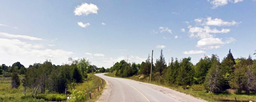
Located south of Tweed (home to a really small jail), Marlbank Road opens up as you come off the shield and creates the perfect contrast to its brethren of the north.  

Please note:  Road surfaces vary from asphalt, to packed tar and chip and seasonal conditions may change or road work may exist.  Always ride with caution.

Accommodations

Accommodations

All of the accommodations listed are Rider Approved and have met or exceeded criteria designed by riders for riders.

Food

Food

There is so much good food along the routes, you will gain weight, we promise. Like a road builder, you've earned a darn good meal.

Attractions

Attractions

It will be tough to get off your bike because the roads are so darn good, but how else will you get the amazing photos to tweet to your friends?

Rest Area

Rest Area

All riders know what 'numb bum' is, and that its your cue to take a break.  Here is a list of places to take a break and enjoy the Highlands.

Distance: 23kms

Area: Marlbank

Map

Downloads

  1. GPX File 1

The Story
  • USA Riders Love Riding the Highlands
  • Ride the Highlands Patch
  • Top 10 Reasons You Should Ride Here
  • Imagine
  • The Road Builders
  • The Man. The Builder
  • The People of the Highlands
The Routes
  • The Highlands Loop
  • Deep Valley Run
  • Dynamite Alley
  • Rideau Ridge
  • Fall Loop
  • Riding and Relaxation
All Listings
  • Accommodations
  • Food
  • Attractions
  • Rest Area
  • Repair
  • Public Washrooms
Top 10 Roads
  • Calabogie, 511 & Centennial Lake Road
  • Siberia Road
  • Rockingham, Letterkenny & Foymount Road
  • Flinton Road
  • Highway 118 & 28 (Carnarvon - Denbigh)
  • Madawaska Road
  • Highway 35 (Norland to Dwight)
  • Elephant Lake, Peterson & Loop Road
  • Old Barry's Bay Road - Palmer Road - Schutt Road
  • Bolingbroke, Mountain & Westport Road
Local Rides
  • Opeongo Loop
  • Meand'rin Motorbikes
  • Valley Sally
  • Calabogie Boogie
  • Curvy Québecor
Adventure Routes
  • Westport Loop - Gravel Crusher Extender Route
  • Gravel Crusher
  • I Ride for Cheese - Gravel Crusher Extender Route
  • Pick-Axe Loop
  • Timber Trail Loop
  • Call My Mom - Timber Trail Extender Route
Must See
  • Algonquin Park Visitor Centre
  • 1840s General Store and Bakery
  • The Rideau Canal National Historic Site Visitor Information Centre
  • Redneck Bistro
  • BeaverTails
  • Kamaniskeg Lake Lookout
  • Dorset Lookout Tower
  • The Shed
  • Eagles Nest Park
  • Marmoraton Mine
Resources
  • Interactive Map
  • Downloads
Social
  • Facebook
  • Blog
  • Youtube
  • Instagram
Sub-Routes
  • Lennox & Addington
  • Haliburton Highlands
  • Ottawa Valley Tourism
  • Rideau Heritage Route
Ontario Rides
  • Discover Motorcycling in Ontario
Canada Logo
ontarion logo alt text
Ontario's Highland Logo
Come Wander Logo
Legal Disclaimer | Privacy Policy

Copyright Ontario's Highlands Tourism Organization. All Rights Reserved.

Photo Credits: School House Museum & Ontario Power Generation, Library & Archives Canada, Marmora Historical Foundation.
 
Funding Provided by the Government of Ontario.